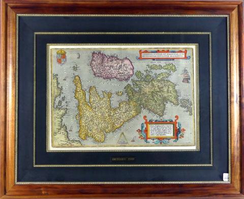
1570 MAP OF ANGLIAE, SCOTIAE, ET HIBERNIAE
This map, Angliae, Scotiae, et Hiberniae, Sive Britannicae, Insularum Descriptio was published at Antwerp by Abraham Ortelius in 1570; Ortelius (1527-1598), a Brabantian cartographer, is recognized
BAUSCH & LOMB MICROSCOPE
Monocular microscope circa 1920 with objectives and eyepieces, made in Rochester, New York and complete with original fitted wood case - height of microscope 26.7cm (10 1/2in)

SEPTENITIONALIUM PARTIUM NOVA TABULA, 1561
This original copper-engraved map by Giulio and Livio Sanuto was created by Girolamo Ruscelli in Venice in 1561 and published in his "Ptolemy’s Geografia"; from Book 4 Descrittione dell’America, li

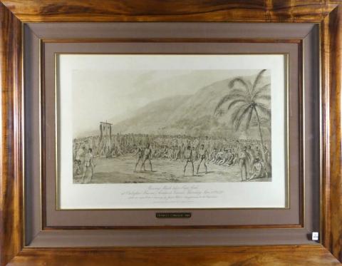
BOXING MATCH BEFORE CAPTAIN COOK AT OWHYHEE
Extremely rare photogravure print in sepia "Boxing Match before Captain Cook at Owhyhee"; the boxing match originally took place on January 28th, 1779 at Owhyhee, Sandwich Islands, present day Hawa

CIRCA 1820 TELESCOPE
A fine single draw telescope with 5.1 centimetre (2-inch) doublet object lens and squared off collar, attributed to Dolland circa 1820; black leather bound, with removable sliding end cap, ray shad

CRATER OF KILAUEA, 1845
This finely crafted and beautifully coloured steel plate engraving was published in 1845 by G.P.

ANTIQUE DESKTOP MAGNIFIER
Manufactured by Watson & Sons, London circa 1880, a heavy desktop magnifier for map reading on a ship - height approximately 35.6cm (14in); adjustable

1872 VOLCANIC ERUPTION OF MAUNA LOA
This original woodblock of Volcanic Eruption of Mauna Loa, Sandwich Islands, was published December 14, 1872, in the Illustrated London News; an especially fine example in rare exceptional conditio
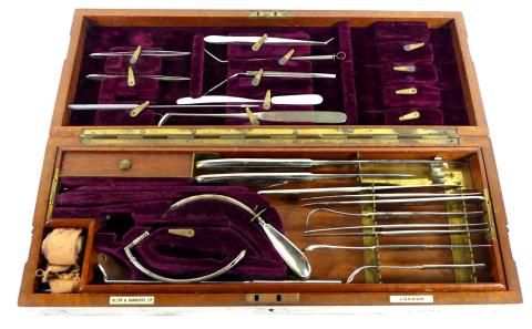
WWI ERA MILITARY SURGERY SET
Extensive British general surgery set circa 1900 by Allen & Hanburys Ltd., London three-tier fitted box with surgery tools (amputation and finger saws, scalpels, trephine, uretones, cannulae, e
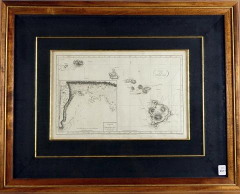
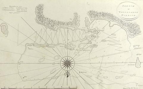
CHART OF THE SANDWICH ISLANDS, 1785
This map represents the historically important first charting of the Hawaiian Islands and was created by Captain James Cook, assisted by William Bligh on Cook’s third and final voyage of Discovery
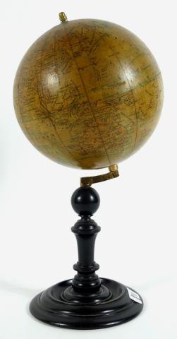
LUDWIG JULES HEYMANN TERRESTRIAL GLOBE
Erd-Globus circa 1907, a fine and large example of superb craftmanship with beautiful and well preserved colouring, ocean currents in finely printed parallel gores over pasteboard sphere with two p
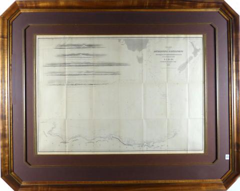
RARE CHART OF THE ANTARCTIC CONTINENT, 1840
The Chart of the Antarctic Continent Shewing the Icy Barrier Attached to it, Discovered by the U.S. Ex.
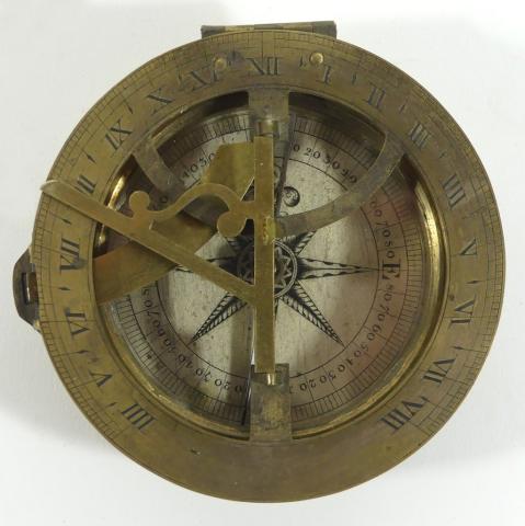
BRASS EQUINOCTIAL COMPASS/SUNDIAL
Circa 1850 brass equinoctial compass/sundial with silvered hour/chapter ring, folding brass gnomen sitting atop a fully functional compass with silvered, four quadrant, engine divided cardinal poin
1845 PORTRAIT OF CHARLES WILKES
Finely crafted steel plate engraving of "Charles Wilkes, Commander, U.S.N.", published in 1845 by G.P.
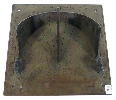
19TH CENTURY CAST BRONZE SUNDIAL
An antique cast bronze 30.5cm (12in) sundial with semi-circular hour ring (hand engraved and divided) with novel sayings around the perimeter in the Georgian and Victorian style; although spuriousl
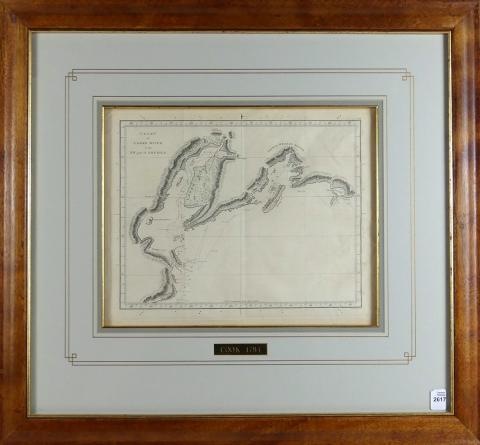
CHART OF COOK'S RIVER IN NW, PART OF AMERICA, 1784
This original copper-plate engraving was published in 1784 by Strahan and Cadell of London, the rare chart shows the path of the Resolution and Discovery as Captain Cook, after discovering the Sand
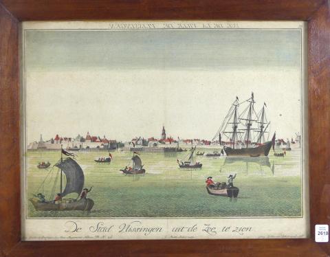
PAIR OF RARE PANORAMIC VIEWS CIRCA 1750
Views of Ville de Vlissingen and Leiden (Netherlands), both hand-coloured perspective aerial maps and in original, fine condition; created by famous cartographers/engravers Probst & Balthasar,

NORTHERN HEMISPHERE, 1802
This rare hand-coloured original copper-plate engraving of the Northern Hemisphere with the North Pole at its centre was published by Wm.

SOUTHERN HEMISPHERE, 1802
This is the companion hand-coloured original copper-plate engraving to the Northern Hemisphere (lot 2619) and is noteworthy for its complete absence of the Antarctic Continent and exhibiting the be
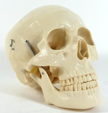
HUMAN SKULL TEACHING MODEL
Mid-20th century scientific teaching model made of composition materials with an articulating mandible (numbered inside jaw), height 17.1cm (6 3/4in)

CRATER OF MOKU-A-WEO-WEO, 1845
This finely crafted and beautifully coloured steel plate engraving was published in 1845 by G.P.

VICTORIAN DESK MAGNIFIER
Antique brass desk magnifier circa 1860, perfect for the philatelist or numismatist; consisting of a solid brass base attached to an adjustable stem by friction fit; the plano-convex lens has no fa
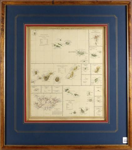
ISLANDS IN THE ATLANTIC, 1844
This important historical map, beautifully hand-coloured and detailed steel plate engraving, was published by and under the Superintendence of the Society for the Diffusion of Useful Knowledge (S.D
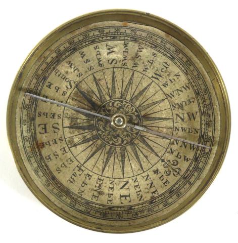
18TH CENTURY MARINER'S POCKET COMPASS
Rare Georgian-era double paper all brass compass with paper dials indicating date of the late 18th century (circa 1790), measures 8.6cm (3 3/8in) diameter; the machining is very fine and early as a
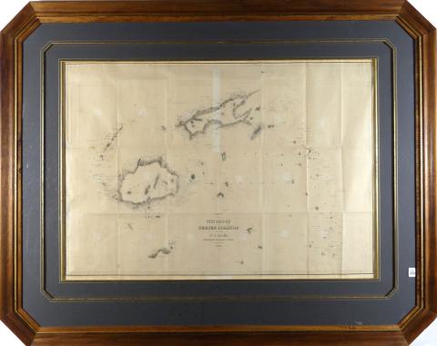
CHART OF THE VITI GROUP OR FIJI ISLANDS, 1840
The Chart of the Viti Group or Feejee Islands by the U.S. Ex.

19TH CENTURY CAPTAIN'S DRAM GLASS
Circa 1860 captain's personal dram glass in a maroon fitted card case and held inside a woven basket with handles, height of glass 5.7cm (2 1/4in)

MAP OF HINDOSTAN, 1814
Original copper-engraved map by Russell with later regional demarcation hand-colouring from Ostell’s New General Atlas, London, 1814; presented in plastic protective sleeve, image size 21.6 x 18.4c
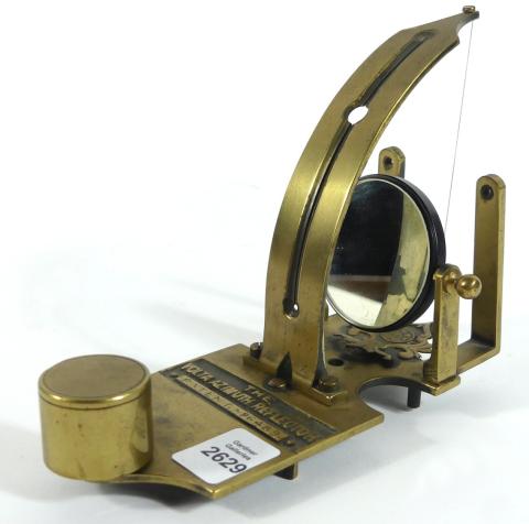
VOLTA AZIMUTH REFLECTOR
Made of brass circa 1895 for obtaining the bearing of the sun, stars and land objects, used with a binnacle compass, in working order - height 12.7cm (5in), length 16.5cm (6 1/2in)

1784 CHART OF THE FRIENDLY ISLANDS
Original charts from Cook’s Third Voyage of Discovery (1776-1779) are distinguished by both their high degree of accuaracy and their historic importance; Captain James Cook singlehandedly mapped th
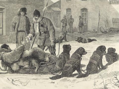
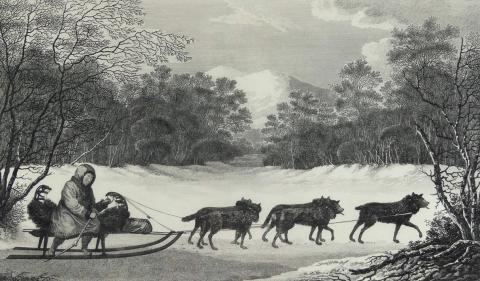
1876 STEEL PLATE ENGRAVING
A rare original steel plate engraving from a painting by English artist Samuel Edmund Waller, illustrating the arrival of a dog sled at Winnipeg, Manitoba, published August 19, 1876 edition of The
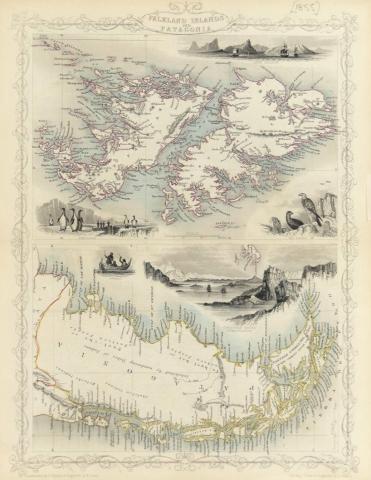
FALKLAND ISLANDS AND PATAGONIA, 1855
An original hand coloured steel plate engraving by J. Rapkin (map) and W. Lacey (illustrations of H.

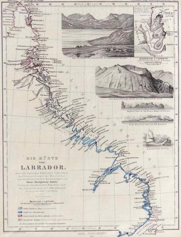
1861 MAP OF THE COAST OF LABRADOR
"Die Kuste von Labrador", an important and rare original engraving illustrating the mapping of the coast of Labrador and showing all major towns with inset detailed landscape views; published by Ju
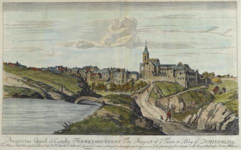
PROSPECT OF YE TOWN & ABBY OF DUNFERMILING, 1693
An exceptionally rare and important original hand-coloured copper-plate engraving from the Theatrum Scotiae by John Slezer, 1693; the latter is considered by scholars to be an important record of S
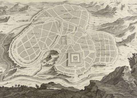
A NEW PLAN OF OLD JERUSALEM, CIRCA 1725-1732
A very rare and important original copper-plate engraved plan of Old Jerusalem from a historical, critical, geographical Bible dictionary of the Holy Bible, printed in 1732 in London (Ref: Vol.
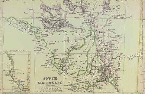
MAP OF SOUTH AUSTRALIA CIRCA 1860
An original hand-coloured steel plate engraving from The Imperial Atlas of Modern Geography, an Extensive Series of Maps published by W.G.
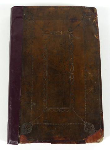
PLAIN AND SPHERICAL TRIGONOMETRY 1706 FIRST EDITION
John Harris' "Plain and Spherical Trigonometry" leather bound book circa 1706 first edition with original owner's signature (J.

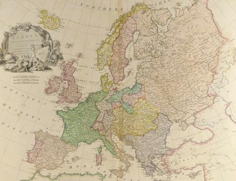
1828 MAP OF EUROPE
This hand-coloured original copper-plate engraving by Sidney Hall, well-known British engraver and cartographer, was first published by Longman, Rees, Orme, Brown and Green of Patternoster Row, Lon
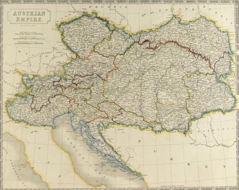
AUSTRIAN EMPIRE, 1828
This hand-coloured original copper-plate engraving by Sidney Hall, well-known British engraver and cartographer, was first published by Longman, Rees, Orme, Brown and Green of Patternoster Row, Lon

ZEISS SILVAMAR BINOCULARS
Pair of Carl Zeiss, Jena 6 x 30mm Silvamar binoculars with original Bausch & Lomb, Rochester, New York leather carrying case with compass to the outside of the lid; made for WWI circa 1916; not
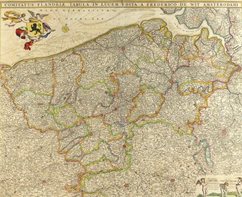
COMITATUS FLANDRIAE TABULA IN LUCEM EDITA A FREDERICO WIT, AMSTERDAM 1680
Rare hand-coloured original fine detail copper-plate engraving by Abraham Deur of Amsterdam, of Flanders; Frederik de Wit (born Frederik Hendriksz in 1629 in Gouda, Holland) was an internationally
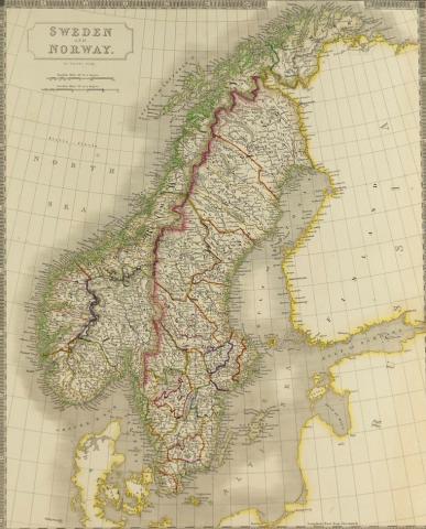
SWEDEN & NORWAY, 1827
This hand-coloured original copper-plate engraving by Sidney Hall, well-known British engraver and cartographer, was first published by Longman, Rees, Orme, Brown & Green of Patternoster Row, L
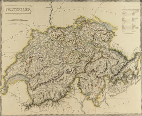
SWITZERLAND, 1828
This hand-coloured original copper-plate engraving by Sidney Hall, well-known British engraver and cartographer, was first published by Longman, Rees, Orme, Brown & Green of Patternoster Row, L
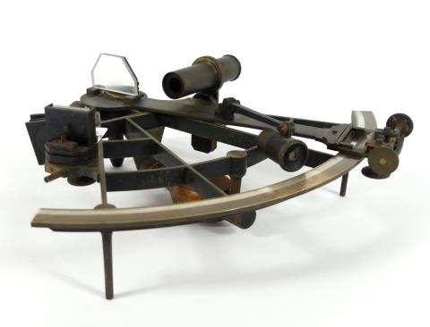
RARE FRENCH SEXTANT CIRCA 1850
A fine and original French sextant with some unusual features and early serial number, signed "E. Lorieux, A.
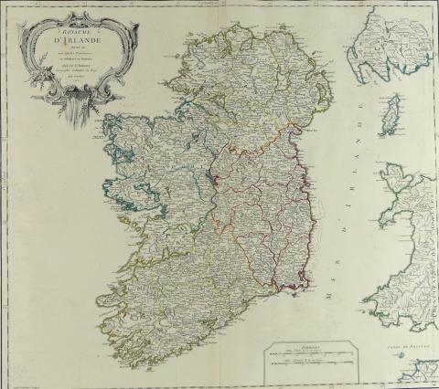
ROYAUME D'IRLANDE, 1750
This rare hand-coloured original copper-plate engraving by Guillaume Delahaye (1724-1803) showing Ireland divided into 4 Provinces was created by Robert de Vaugondy, Cartographer to King Louis XV o
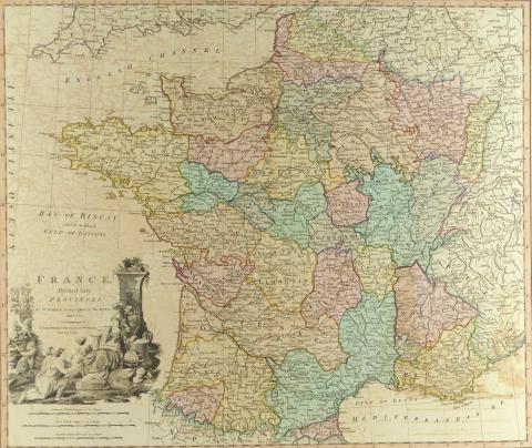
1790 MAP OF FRANCE
This rare hand coloured original copper-plate engraving of France divided into Provinces was published by W.

CODDINGTON LENS IN BRASS FRAME
Late 19th century brass one-piece Coddington lens in near perfect condition, large proportions, with single lens ground on both sides - length 14cm (5 1/2in)
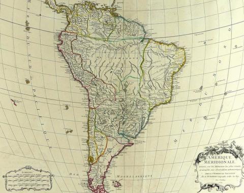
AMERIQUE MERIDIONALE, 1750
This rare hand coloured original copper-plate engraving by Robert de Vaugondy, Cartographer to the king of France (Louis XV), who, in 1757, together with his son Didier, published The Atlas Univers
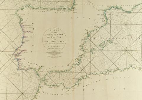
1780 CHART OF THE COASTS OF SPAIN & PORTUGAL
This rare large and detailed hand-coloured original copper-plate engraving was published by William Faden at Charing Cross, London, on June 28, 1780, in his capacity as successor to the late T.
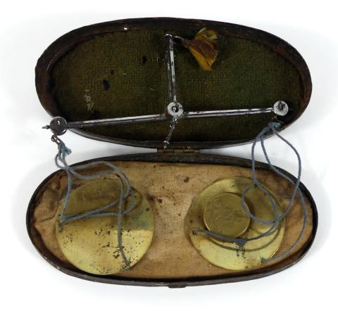
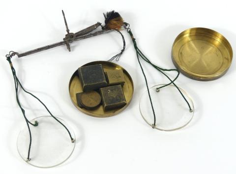
ANTIQUE COIN SCALE
Pair of equal arm coinage/gold scales in oval, black enamelled metal case with baize and silk liner; finely chiselled steel beam, gallows, indicator, end caps and pivot points; original stringing t
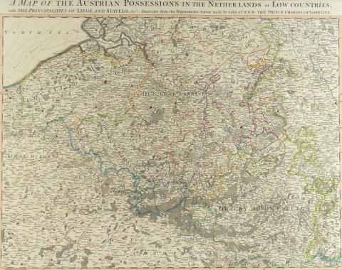
MAP OF THE AUSTRIAN POSSESSIONS IN THE NETHERLANDS, 1789
This rare hand coloured original copper-plate engraving which also includes The Principalities of Liege and Stavelo, was reduced from the Trigonometric Survey made by order of H.R.H.
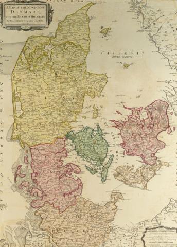
MAP OF THE KINGDOM OF DENMARK WITH THE DUCHY OF HOLSTEIN, 1790
This rare original copper-plate engraving by William Faden, Geographer to the King, was printed at Charing Cross, London, on August 2, 1790, highly detailed showing all Royal Post and other roads a
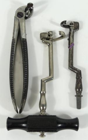
CIRCA 1860 DENTAL TOOLS
A grouping of three 19th century dental tools including two dog leg tooth keys and a signed molar extractor; universal ebony grip for the keys (one with quick change spring for the claw, the other

1790-1792 MAP OF FRANCE
This important hand-coloured original copper-plate engraving shows France divided into Metropolitan Circles, Departments and Districts as decreed by the National Assembly on January 15, 1790; the N

THE RUSSIAN DOMINIONS IN EUROPE, 1808
This very rare and extraordinarily detailed hand-coloured original copper- plate engraving comprises two separate large maps which were drawn from the latest maps printed by the Academy of Sciences
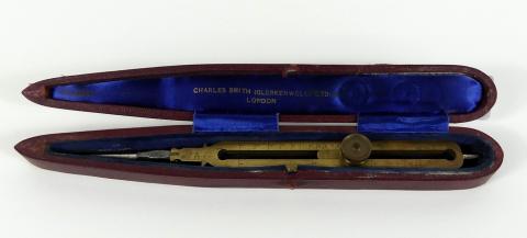
PROPORTIONAL DIVIDERS BY CHARLES SMITH
A fine cased pair of large proportional dividers circa 1840 in tapering Victorian-style maroon case with Royal blue velvet lining; fully functional, length 22.9cm (9in); also included is a 19th cen
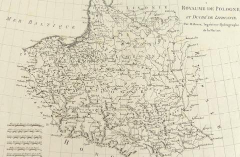
ROYAUME DE POLOGNE ET DUCHE DE LITHUANIE, 1787
A rare detailed, original copper-plate engraving by Jean Andre, from a map by M. Bonne, Ingenieur-Hydrographe de la Marine, and published in Rigobert Bonne’s "Atlas Encyclopedique Par M.

BRASS & HORN STEEL FLEAM
Antique three-bladed fleam constructed of steel blades and horn protective sleeve, signed "Premier, F. Newton" - length closed 8.3cm (3 1/4in)
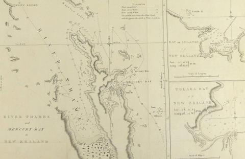
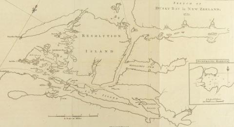
RIVER THAMES AND MERCURY BAY IN NEW ZEALAND, 1773
A very rare original copper-plate engraving from John Hawksworth’s 1773 account of Cook’s first voyage of discovery showing the route taken by the Endeavour in 1769, and printed for W.
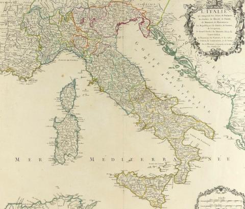
1750 MAP OF ITALY
A rare original large outline hand-coloured highly detailed copper-plate with fine cartouche, engraving by Robert de Vaugondy and included in his Atlas Universel of 1757; De Vaugondy’s maps are con
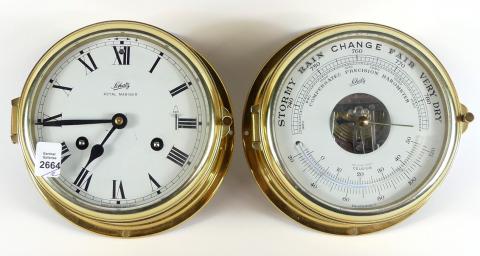
PAIR OF NAUTICAL BULKHEAD INSTRUMENTS
Manufactured by Schatz, Royal Marine brass key-wind clock and barometer, complete with two keys and original instruction booklets, circa 1950's - diameter for each approximately 17.8cm (7in)

THE DEATH OF CAPTAIN COOK, 1785
This very rare larger format original copper-plate engraving by famed Italian master craftsman Francesco Bartolozzi R.A.(1727-1818) for the figures, and William Byrne (1743-1805) for the landscape,
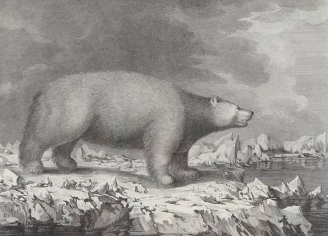
A WHITE BEAR, 1784
A rare original copper-plate engraving by Peter Mazell from a drawing by John Webber showing a polar bear on ice, from an account of Cook’s third and last voyage (Plate73); the bear was encountered
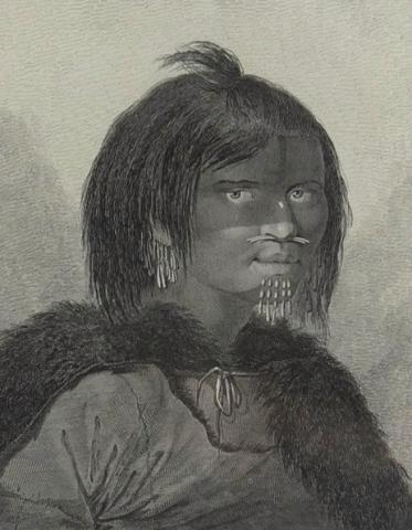
A WOMAN OF PRINCE WILLIAM SOUND, 1784
A rare original copper-plate engraving by James Basire (1730-1802) of London, from a drawing by James Webber from an account of Cook's third and last voyage (Plate 47); Webber's illustrat

INHABITANTS OF NORTON SOUND AND THEIR HABITATIONS, 1784
A rare original copper-plate engraving by Benjamin Thomas Pouncy, from a drawing by John Webber from the official British Admiralty sanctioned edition of the account of Cook’s third and last voyage
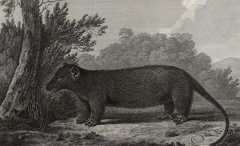
AN OPOSSUM OF VAN DIEMEN'S LAND, 1784
A rare original copper-plate engraving by Peter Mazell, from a drawing by John Webber from the official British Admiralty sanctioned edition of the account of Cook’s third and last voyage (Plate 8)

CASED MOUNTED TELESCOPE CIRCA 1880
A 1 1/8in (2.9cm) diameter, three-drawer telescope with mahogany barrel, mounted on an adjustable brass stand with a maximum height of 30.5cm (12in), that threads into a brass ferule on the lid of

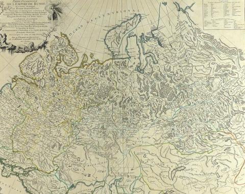
PARTIE SEPTENTRIONALE DE LA RUSSIE EUROPEENNE, 1753
A rare, large and extremely detailed, original outline hand-coloured copper-plate with fine title cartouche, engraving by Robert de Vaugondy from details of the Russian Atlas printed in September 1
PARTIE OCCIDENTALE DE L’EMPIRE DE RUSSIE, 1750
A rare, large and highly detailed, original outline hand-coloured copper- plate with fine decorative title cartouche, engraving by Robert de Vaugondy including details of the Russian Atlas printed

LA PRUSSE, 1751
A rare, large and highly detailed, original outline hand-coloured copper-plate with fine decorative title cartouche, engraving by Robert de Vaugondy

CAPTAIN'S PORTABLE CUP
A fine 19th century portable collapsible silver-over-copper cup/mug, with folding handle and half card case, circa 1880 - height of cup fully extended 5.7cm (2 1/4in)
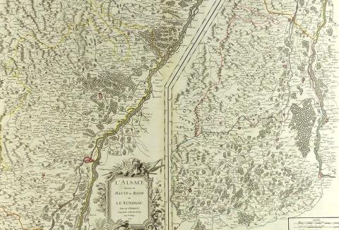
L’ALSACE, 1754
A rare, large and highly detailed, original outline hand-coloured copper- plate with fine decorative title cartouche, engraving by Robert de Vaugondy; this is a scarce and beautiful map of the Alsa
1791 MAP OF EUROPE
A rare, very large and detailed original hand-coloured copper-plate with fine decorative title cartouche showing a Queen holding a scepter watching over three children as they appear to study a map
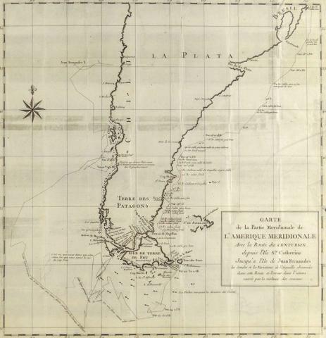
CARTE DE LA PARTIE MERIDIONALE DE L’AMERIQUE MERIDIONALE, 1750
This rare original copper-plate engraving by Jean Lattre (an important Paris-based bookseller, map publisher, and calligrapher) was included in the 1750 French edition of a 1744 Voyage Round the Wo
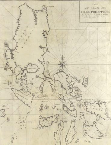
CARTE DU CANAL DES ISLES PHILLIPPINES, 1750
This rare original copper-plate engraving of the Northern Philippine Islands is considered one, if not the most important, of the maps relating to Anson’s circumnavigation of the world and was incl
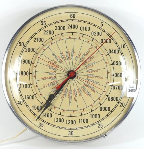
VINTAGE WORLD CLOCK
1949 copyrighted vintage 24-hour electric world clock with glass cover and in working order, diameter 26cm (10 1/4in); Timing Devices Co., Springfield, Massachusetts
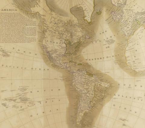
IMPORTANT LEWIS & CLARK MAP OF THE AMERICAS CIRCA 1815
Early 19th century John Thomson map of the Americas titled to the upper margin "America with the Latest Discoveries of Humboldt, Clarke, Lewis", engraved by J & G Menzies circa 1815; this map s
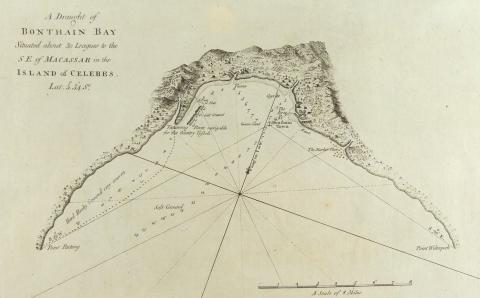
A DRAUGHT OF BONTHAIN BAY… IN THE ISLAND OF CELEBES, 1790
An original copper-plate engraving copied from John Hawkesworth’s accounts of circa 1774 of Cook’s and other explorers’ voyages of discovery, and published by Alexander Hogg, London, in 1790; the m

A CHART OF THE ISLANDS DISCOVERED IN OTAHEITE, CIRCA 1780
An original copper-plate engraving likely copied from John Hawkesworth’s accounts of c.1774 of Cook’s and other explorers’ voyages of discovery, and published by Alexander Hogg, London, around 1780
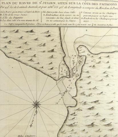
PLAN DU HAVRE DE ST. JULIEN, SITUE SUR LA COTE DES PATAGONS, CIRCA 1750
A rare original copper-plate engraving (Tom.
ANTIQUE PRISMATIC COMPASS
Mahogany cased, green card English prismatic compass, 7.6cm (3in) diameter; sighting is done through the prism to read the compass; sighting vane knurled knob stops and locks the compass; a fine ex
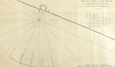
DISPOSITION DES VAISSEAUX DE L’ESCADRE...D’ACAPULCO EN 1742, CIRCA 1750
A rare original copper-plate engraving (Tom.
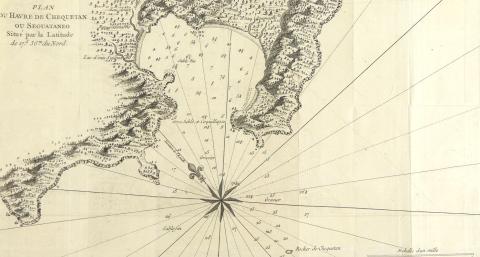
PLAN DU HAVRE DE CHEQUETAN OU SEGUATANEO CIRCA 1750
A rare original copper-plate engraving (Tom.

18TH/19TH CENTURY MAHOGANY PLAQUE
Richly carved armorial wall plaque/panel insert circa late 18th/early 19th century, 33.7 x 30.5cm (13 1/4 x 12in)
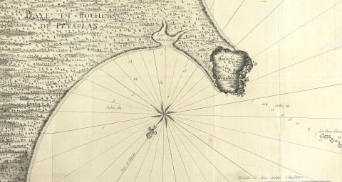
BAYE ET ROCHERS DE PETAPLAN, CIRCA 1750
A rare original copper-plate engraving (Ref: Planche XVII, Tome.


PLAN DE L’EXTREMITE ORIENTALE DE L’ILE DE QUIBO CIRCA 1750
A rare original copper-plate engraving (Tome.

ART DECO OPERA GLASSES
A fine pair of art deco opera or field glasses with knurled bakelite adjustment wheel, special anniversary edition dated 1928 with a patent date of 1916, signed for Bausch & Lomb, Rochester, Ne
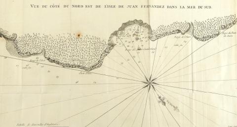
VUE DU COTE DU NORD EST DE L’ILE JUAN FERNANDEZ DANS LA MER DU SUD, CIRCA 1750
A rare original copper-plate engraving (Ref : Planche VI, Tom.

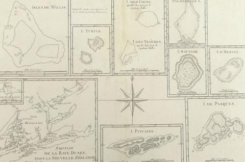
ISLE DES COCOS, ISLE DES TRAITRES, 1774
A rare original copper-plate engraving (Ref : Tome II, Pl.
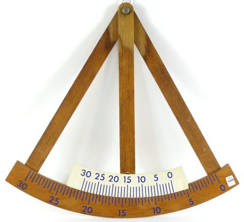
NAUTICAL INCLINOMETER
A vintage wood ship's pendulum inclinometer circa early 20th century, used for measuring angles of slope/tilt or elevation of an object with respect to gravity's direction - dimensions ap

CHART OF COOK’S STRAIT IN NEW ZEALAND, 1773
A very rare first edition copper plate engraving by John Ryland from John Hawkesworth’s "Account of the Voyages undertaken by Order of his Present Majesty for Making Discoveries in the Southern Hem
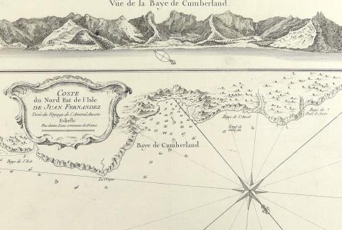
COSTE DU NORD EST DE L’ILE JUAN FERNANDEZ, CIRCA 1757
A rare original copper-plate engraving (Ref; Tome XI No. 7) from Admiral George Anson’s 1740 Voyage around the world, and published in Paris, France c.1757

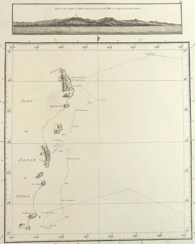
SULPHUR ISLAND, 1785
A rare original detailed topographical copper-plate engraving (Plate 80) by Harmar after a missing survey possibly by William Bligh in November 1779 on Cook’s Third Voyage, and published in 1785 by

ILLUSTRATION OF A PLANETARY ORRERY
Original watercolour and graphite drawing of an orrery, signed and dated (19)86 upper right, paper on card, 61 x 45.7cm (24 x 18in); unframed; Note: an orrery is a mechanical model of the Solar Sys

SKETCH OF THE HARBOURS ON THE NORTH SIDE OF EIMEO, 1784
A rare original detailed topographical copper-plate engraving (Plate 50) from William Bligh in December 1777 on Cook’s Third Voyage, and published in 1784 by Order of the Lords Commissioners of the

WANOOA-ETTE, WATEEOO, MANGEEA, TOOBOUAI ISLANDS, 1784
A rare original copper-plate engraving (Plate 24) from a survey of 4 south Pacific Islands by William Bligh in 1777 on Cook’s Third Voyage, and published in 1784 by Order of the Lords Commissioners

PLAN OF ADVENTURE BAY ON VAN-DIEMEN’S LAND, 1784
A rare original copper-plate engraving (Plate 9) from an original 1773 survey of Capt. Tobias Furneaux, copied by Lt.
19TH CENTURY APOTHECARY SCALE
Including a 19th century glass apothecary scale and 6.4cm (2 1/2in) diameter brass tin with assorted weights inside; old fitted box included (hinge broken)
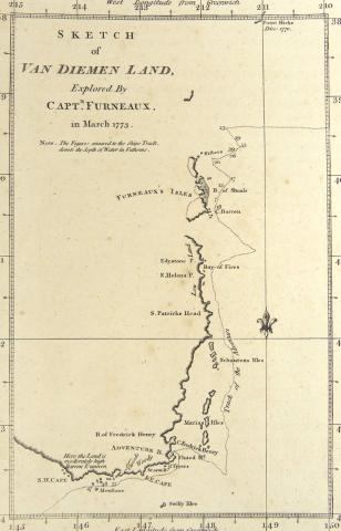
SKETCH OF VAN-DIEMEN’S LAND, 1777
A rare original copper-plate engraving by J. Russell (Plate No. VIII) of a survey by Capt. Furneaux, from A Voyage towards the South Pole by Capt.
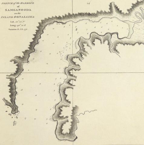
SKETCH OF THE HARBOUR OF SAMGANOODA ON THE ISLAND OONALASKA, 1784
A rare original copper-plate topographically detailed engraving by (Thos.) Harmar (Plate 33) from a drawing by Henry Roberts from Cook’s Third Voyage, and published in 1784 by Order of the Lords Co

LUSTREWARE CIRCA 1830
Sunderland and Tyne/Seaham English lustreware charger circa 1830 with image of "The Mariner's Compass", 20.3 x 22.9cm (8 x 9in)

SKETCH OF THE TYPA AND MACAO, 1785
A rare original copper-plate topographically detailed engraving by W.
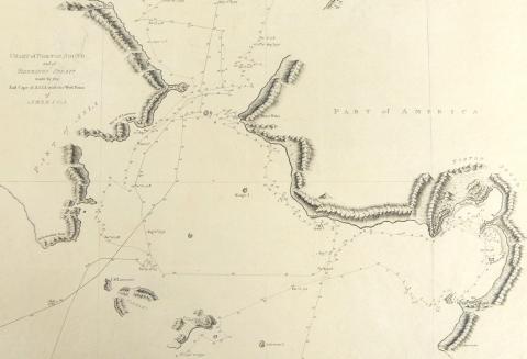
CHART OF NORTON SOUND AND OF BHERINGS STRAIT, 1784
A rare original copper-plate topographically detailed engraving (Plate 53) from Cook’s Third Voyage, and published in 1784 by Order of the Lords Commissioners of the Admiralty, printed by W.

CHART OF COOKS RIVER IN THE N.W. PART OF AMERICA, 1784
A rare original copper-plate highly topographically detailed engraving (Plate 44) with Writing by W.

18TH CENTURY ZODIAC PRINT
Original hand-coloured print from a German cosmograph atlas circa 1761 with image of a ring dial, seasons and zodiac - sheet size 32.1 x 21cm (12 58 x 8 1/4in), matted, in plastic sleeve
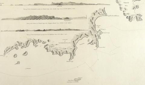
CHART OF VAN DIEMEN’S LAND, 1784
A rare original copper-plate engraving by Thomas Harmar (Plate 5) from drawing by Lt.
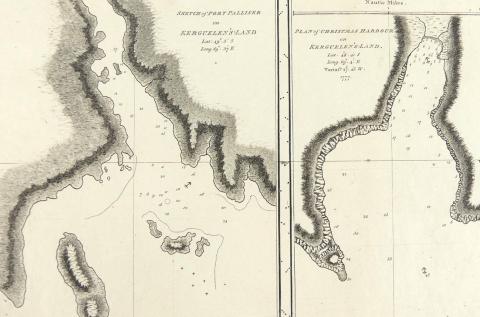
SKETCH OF PORT PALLISER AND PLAN OF CHRISTMAS HARBOUR, 1784
A rare original copper-plate topographically detailed engraving (Plate 3) from Cook's Third Voyage, and published in 1784 by the Order of the Lords Commissioners of the Admiralty, printed by W.

ISLES DE LA REINE CHARLOTTE, 1774
A rare original copper-plate engraving by Robert Bernard (Ref: Tome I, Pl.
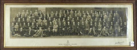
1925 PHOTOGRAPH & DIPLOMA
"Royal Veterinary College, London, 1925" class photograph, frame outside dimensions 29.2 x 77.5cm (11 1/2 x 30 1/2in); together with a diploma (unframed) from class member Edward George Comisbee

TERRE DE KERGUELEN, 178
A rare original detailed copper-plate engraving by Jean Andre (Plate 140) from the work of M.
NOUVELLE HOLLANDE, 1788
A rare original highly detailed copper-plate engraving (Plate 137) from M.
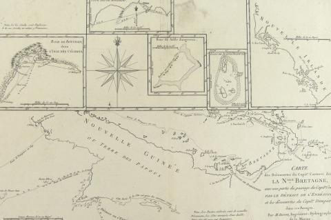
CARTE DE LA NLLE BRETAGNE, 1788
A rare original interesting and detailed copper-plate engraving by Jean Andre (Plate 136) from the work of M. Bonne, Ingenieur Hydrographe de la Marine, based on the accounts of Capt.
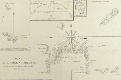
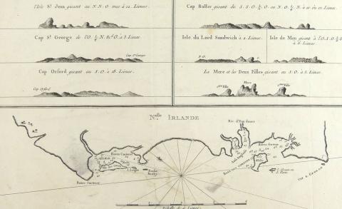
ISLES DE LA REINE CHARLOTTE, 1788
A rare original detailed copper-plate engraving by Jean Andre (Plate 135) from the work of M. Bonne, Ingenieur Hydrographe de la Marine, based on the accounts of Capt.

ISLES DES NOUVELLES HEBRIDES ET CELLE DE LA NOUVELLE CALEDONIE, 1788
A rare original decorative and detailed copper-plate engraving (Plate 134) by Jean Andre from M.

CARTE DE LA TERRE VAN-DIEMEN 1788
A rare original detailed copper-plate engraving with large compass rose by Jean Andre (Plate 133) from the work of M.

RARE MAP OF MEXICO & CENTRAL AMERICA CIRCA 1700
From the Nouvel Atlas, Covens & Mortier, an early hand-coloured map of Mexico and Central America by Pieter van der Aa, the rare point of mention is that California is shown as a small island t
LA NOUVELLE ZEELANDE, 1788
A rare original interesting and detailed copper-plate engraving by Jean Andre (Plate 132) from the work of M. Bonne, Ingenieur Hydrographe de la Marine, based on the accounts of Capt.
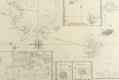
CARTE DES ISLES DES AMIS, 1788
A rare original detailed copper-plate engraving by Jean Andre (Plate 129) from the work of M.
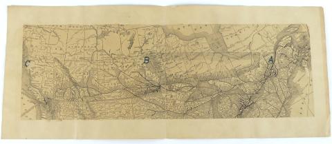
EARLY MAP OF CANADIAN INTEREST
Antique folding map depicting rivers, lakes and rail transport, from British Columbia to the Gulf of the St.
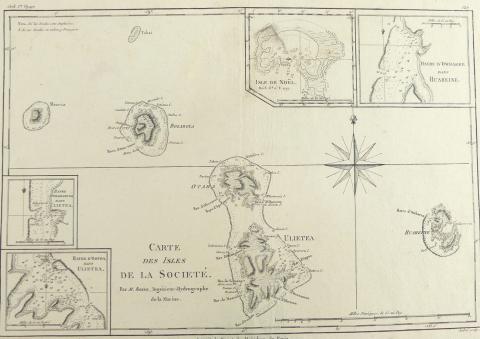
CARTE DES ISLES DE LA SOCIETE, 1788
A rare original detailed copper-plate engraving by Jean Andre (Plate 127) from the work of M.
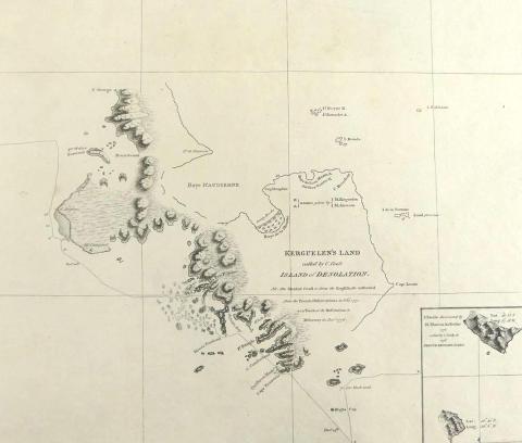
KERGUELEN’S LAND, 1785
A rare original very detailed copper-plate engraving (Plate 2) from a drawing by Lt.

BRASS STATION POINTER BY HUGHES, CIRCA 1910
Antique brass station pointer made circa 1910, 22.9cm (9in) circle with two movable arms both fitted with tangent screws, with micrometer drums movable through a 360 degree circle and three extensi
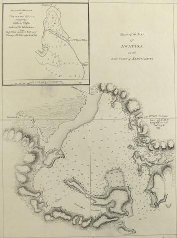
PLAN OF THE BAY OF AWATSKA, 1785
A rare original very detailed copper-plate engraving (Plate 69) from the 1785 account of Cook’s Third Voyage, by W.H(arrison) and includes an inset Plan of the harbour off St. Peter and St.
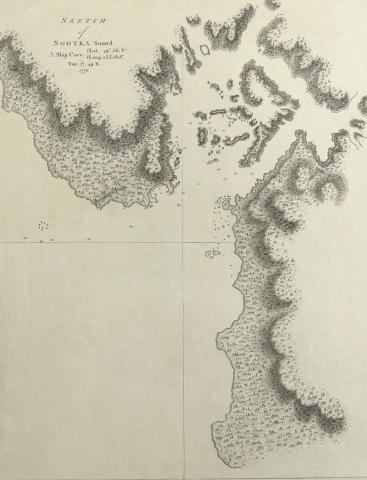
SKETCH OF NOOTKA SOUND 1785
A rare original very detailed copper-plate engraving (Plate 37 - the writing engraved by Mw. Smith) from the 1785 account of Cook’s Third Voyage, copied by Lt. Henry Roberts for publishers G.

TWO JOHN SPEED MAPS CIRCA 1676
Two stunning John Speed (1540-1622) maps Including "Kent, with Her Cities and Earles Described and Observed", and "Buckingham" which shows "The Armes of the Honorable Famil
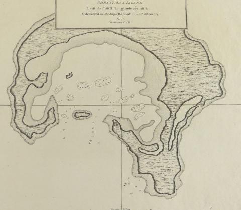
CHRISTMAS ISLAND, 1785
A rare original copper-plate engraving (Plate 32) from the 1785 account of Cook’s Third Voyage, by William Bligh and published by G. Nicol and T.
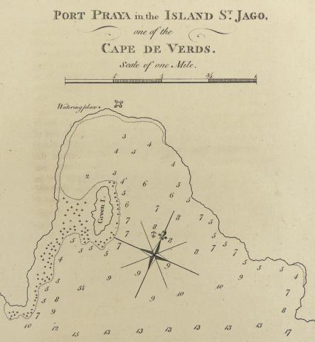
PORT PRAYA IN THE ISLAND OF ST. JAGO, 1777
A rare original copper-plate engraving (Plate No. X) from A Voyage towards the South Pole by Capt. James Cook, (2nd Voyage), published on February 1, 1777, by Wm.

SKETCH OF THE MARQUESAS DE MENDOCA, 1777
A rare original copper-plate engraving (Plate No. V) from A Voyage towards the South Pole by Capt. James Cook (2nd Voyage), published on February 1st, 1777 by Wm.

18TH CENTURY EMANUEL BOWEN MAP OF THE BRITISH ISLES
Bowen's map of the British Isles from "A Complete System of Geography", with an elaborate allegorical naval cartouche and two compass roses, published London, 1747; titled "A Ne
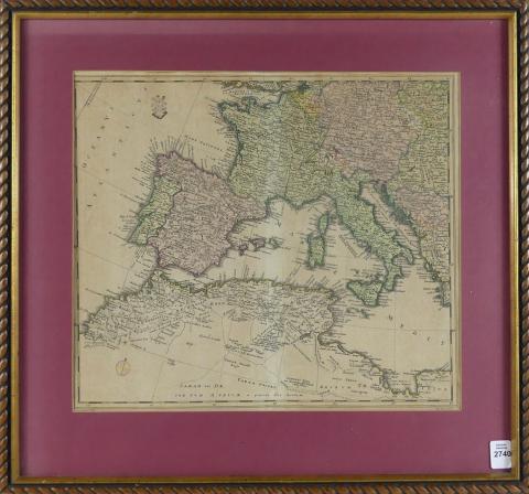
WESTERN EUROPE & NORTH AFRICA, CIRCA 1778
A rare and important map of Western Europe and North Africa by Friedrich Wilhelm Karl Von Schmettau, written completely in Latin circa 1778; from an atlas and with original hand-colouring, fold and
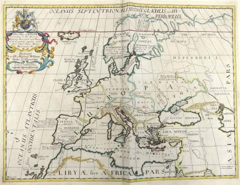
NEW MAP OF EUROPE BY EDWARD WELLS, CIRCA 1712
With Royal Coat of Arms and dedication to William, Duke of Gloucester; part of an atlas produced while the Duke was at Oxford; the map displays capital cities, rivers and mountains, written in Lati
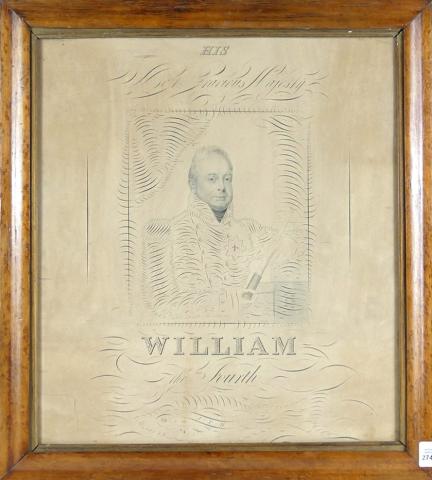
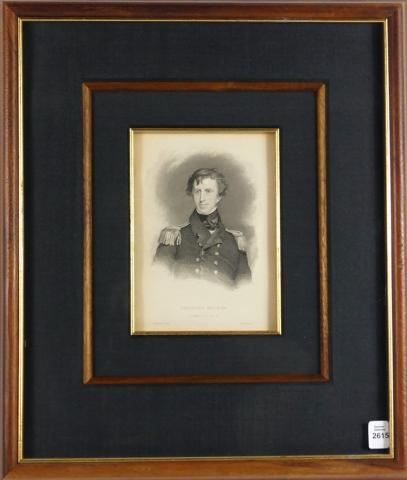
18TH CENTURY PORTRAIT ENGRAVING
With an image of The Duke of Clarence, who commanded the Royal Navy ships from 1786-1790 under Lord Nelson and known as "The Navy King"; the print has a dedication to "His Most Gracious Majesty, Wi
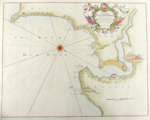
18TH CENTURY CHART OF KINGSALE HARBOUR
18th century sea chart showing The Bay of Old Head, and Part of Cork and County, Published by Freeman Collin, London; the chart is decorated with a compass rose and richly decorated title cartouche
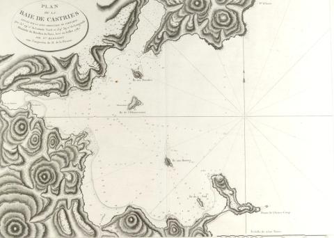
PLAN DE LA BAIE DE CASTRIES MAP
Original copper-plate engraving of visitations in July, 1787and published in 1797-1798 in Atlas du Voyage de la Perouse; presented in fine condition in mat form and is an important and impressive f

CARTE DE L'ARCHIPEL DES NAVIGATEUS
Original copper-plate engraving published in 1797-1798 in Atlas du Voyage de la Perouse (Plate 52), visitation in December, 1787; this large and handsome charting depicts the islands of Samoa with
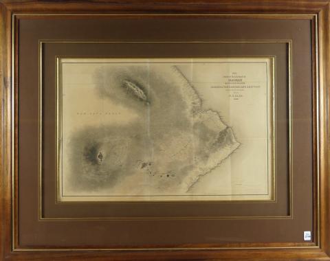
19TH CENTURY MAP OF HAWAII
"Map of Part of the Island of Hawaii, Sandwich Islands Shewing Craters and Eruption of May and June, 1840"; finely crafted and beautifully coloured steel plate engraving, from the 1841 Un
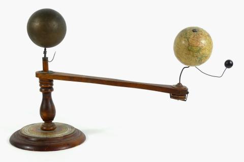
TRIPPENSEE PLANETARIUM ORRERY
An educational mechanical model used to demonstrate the relative positions of the earth and moon to the sun, handmade with wood, metal and papier-mâché, in all original condition circa early 1900's

TWO RULERS INCLUDING 18TH CENTURY
An 18th century Gunter's boxwood rule measuring 61cm (24in) scaled for navigation, developed after the logarithm of 1620; the other signed for J.